
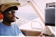
Since my last posting, I have taken my required long
cross-country. My long cross-country was from Cuyahoga County Airport to Wheeling
West Virginia Airport, New Philadelphia Airport, and back home to Cuyahoga
County Airport.
The trip to Wheeling West Virginia overall went quite well,
and my checkpoints were all within two minutes, and the checkpoints were right
where they should’ve been. The only issue that was problematic in a minor way
was the turbulence. After takeoff I climbed to 5500 feet and was able to hit my
altitude and headings with not much of a problem, except my playing kept
wanting to turn to the right, however in the Cherokee you have a rudder trim
therefore I was able to control it somewhat.
One of my shortcomings is that I have to watch my frequencies because I
tried to call Akron Approach Control on the wrong frequency. As I approached Steubenville Ohio I had to
tuck under the Bravo airspace which once again brought back the turbulence that
I was trying to avoid. While I was on a 4 mile final a Cessna on an animal
rescue mission was on base so I offered a 360 to let the critters land first, which
the tower approved.
Once on the ground I was able to meet my friends for lunch which was a treat, because we have been talking about me flying over for lunch for a couple of years. Unfortunately, I was on a shorter schedule so I could not hang around and was able to get off the ground within an hour and a half and flew to my next destination, New Philadelphia.
Once on the ground I was able to meet my friends for lunch which was a treat, because we have been talking about me flying over for lunch for a couple of years. Unfortunately, I was on a shorter schedule so I could not hang around and was able to get off the ground within an hour and a half and flew to my next destination, New Philadelphia.
This leg was a little more difficult because I was not paying attention to my headings like I should’ve been. I found myself flying north of my route therefore I missed my check point, Cadiz, Ohio, birthplace of what famous actor? I was able to get myself back on route without much of a problem, however finding that airport was not easy and I ended up cheating by using the panel mounted GPS. This is something I did not want to do, however, if you have those tools available to you, you might as well use them. I could’ve used my Garmin Pilot but I did not want to reach back into my flight bag and dig it out of the bag. I later on found out that other pilots have had the same problems in locating this airport, and recall years ago as a passenger we had same issue. This airport is kind of tucked in some trees on one side and hard to find unless you know what you’re looking for.
The final leg was very interesting however very simple. From the airport to the VOR to my home airport is pretty much a straight shot and maybe 2° or 3° difference over the VOR. Working with Akron control was no problem, and flying over both Akron airports was pretty easy, and flying through the Charlie airspace was also easy especially on a Sunday when there are not too many airliners taking off from Akron.
So, the long cross-country was pretty much an easy process
and all of my times were pretty much on except for the one leg which I was able
to press on to my destination. I believe that as many other people have
experienced, this type of cross-country is a big boost to the ego and you also
feel like a real life pilot. Oh wait, I almost am a real life pilot.

1 comment:
No matter the experience, some airports are just darn hard to locate. I still occasionally run into one that I don't seem to spot until stumbling over top. Always a skill to continue honing!
Post a Comment